The idea of FotoQuest Go is added to other similar
applications of the Geo-Wiki platform of
the IIASA, such as Pictures
Geo-Wiki or LACO-Wiki ,
aimed at the collaborative mapping of coverage and land use around the world. The
foundation of the new campaign with FotoQuest lies in the study of the
fragmentations and variations in the coverage of the territory through
predefined geographical places from where we will have to answer some simple
questions and photograph the environment. For this, FotoQuest Go, has 340,000 points previously photographed and georeferencedthat
need to be updated in the new campaign. From your app you can identify the
places closest to you and visit them to earn symbolic savings mapping. The
application will ask you to photograph the point where you are and indicate the
variations of land cover that there is currently. For each visited point
you will receive between € 1 and € 3 based on the
degree of proximity or accessibility to the place.
The application is freely
available for download from the APP Store and
from Google Play . Once
downloaded, you will be able to log in and begin to visualize the ranking of
volunteer mappers, the thousands of territorial points that are close to you
and their amounts of 1, 2 and 3 euros. Weekly, a surprise point of € 30
can appear anywhere in the geography to be mapped equally.
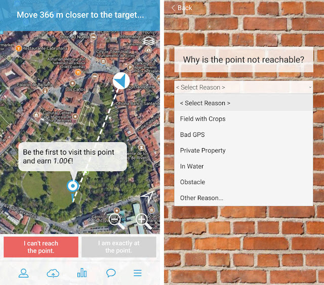
Once the application is installed,
you will observe the points to visit next to you from the viewer of the
application. When you are less than 500 meters from a point, you can start
to manage the information by accessing the query questionnaire. In case of
not being able to access the point for reasons of security, privacy or
barriers, we can indicate it from the application. Otherwise we can move
to the exact place.
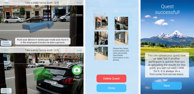
At the moment you are
in the place of the point to map you will observe a repertoire of images
captured in past moments with which to begin to contrast the current
information. We will only have to answer two simple questions raised by
FotoQuest Go. One linked to changes in current land use , another linked to distances and, finally, the application
assistant will ask us to take a series of photographs to
contrast the previous information with the current one.
Once the questionnaire is finished,
we can access the image editing assistant if we wish to erase and hide private
data such as people, addresses or license plates. After sending the
information, we will receive the validation of the information and, in case of
complying with the requested requirements, the amount will be added to the
money exchange of FotoQuest Go through a PayPal account.
You can check the
current situation of the map to explore the mapping status of your territory through
this map , knowing the POI of greater and lesser amount and all those
places that have already been visited. From the FotoQuest Go app you will
have the monitoring of these points in real time knowing the precise distance
to them.
Remember not to fall
into excess of vice and do any barbarity to accumulate money. Always watch
the roads, ravines and any danger around during the data collection and enjoy
mapping while you get savings and aid to the scientific community.


intrested
ReplyDeleteI have never done such things before. When it comes to online currency exchange, a very good place for this is conotoxia where we can exchange money whenever we want. In my opinion this is a great place to exchange money.
ReplyDeleteI am questioning that during this time you must deliver a try and this new app Covet Fashion Mod Apk : which is now maximum trending app inside the global.
ReplyDelete